")
By Warda Rafaqat, PhD Candidate, Western Norway University of Applied Sciences and University of Bergen
The 2018 season was not an isolated anomaly. It was an indication of a changing wildfire risk landscape in Norway.
Wildfires in Norway
Despite its northern climate, Norway experiences over 1,200 wildfires annually, with an average of around 2,000 hectares burned each year. Analysis of wildfire records from 2016–2023 reveals clear patterns in where and when fires occur.
Wildfire activity is not evenly distributed across the country. Southeastern Norway shows a significantly higher concentration of incidents, while northern regions still experience fewer fires, though risk is gradually increasing there as well.
Figure 1 – Wildfire distribution map (2016–2023)
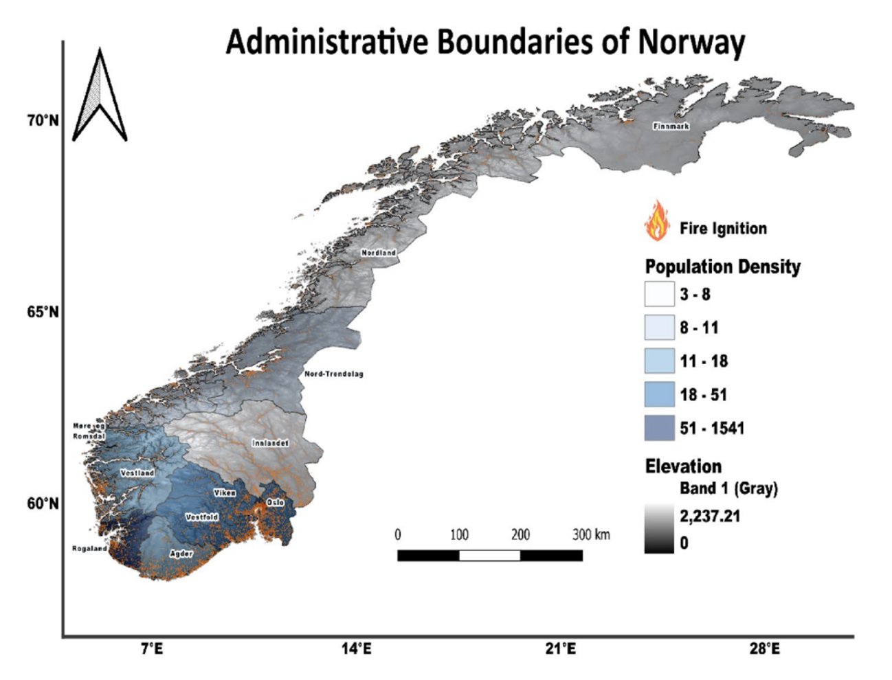
Spatial distribution of wildfires in Norway, showing a higher concentration in Southeastern regions compared to the north.
This spatial pattern highlights that wildfire risk is closely linked to population density, human activity, and local climatic conditions. Many incidents occur near roads, settlements, and recreational areas, making wildfires not only an environmental issue but also a civil protection challenge.
Suthern Norway experiences the highest activity, especially in Viken, Agder, and Rogaland, where population density, forest cover, and tourism increase exposure. In contrast, northern regions such as Nordland and Troms still face fewer fires, but reports indicate a steady rise. Figure 2 in the study highlights this strong north–south gradient, showing how wildfire probability gradually increases toward the southern coastal and inland regions.
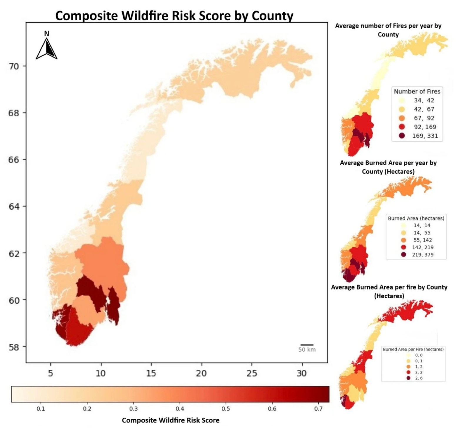
The research developed a composite wildfire risk map that integrates climate variables, vegetation data, elevation, and human density. The results show clear regional differences:
- Very high risk: Rogaland, Viken, and Agder
- Moderate risk: Trøndelag and Innlandet
- Low to very low risk: Møre og Romsdal, Nordland, Troms, and Finnmark
These findings align with Norway’s climatic zones. Southern regions face prolonged summer droughts, while northern regions experience shorter dry periods but increasing temperature anomalies.
Fire frequency is also higher in coastal zones compared to high-altitude inland areas due to vegetation type (heathlands and coniferous forests). The study’s visualizes these differences, showing a clear spatial pattern of increasing risk toward southern Norway.
The number of municipalities affected by wildfires also grew from 75 in 2005 to 176 in 2018, indicating how widespread the risk has become.
Spring: Norway’s Most Critical Fire Period
One of the most important findings is that wildfire occurrence peaks in April and May. This early-season peak is linked to dry vegetation after snowmelt, wind conditions, and increased outdoor human activity.
Figure 3 – Monthly wildfire frequency
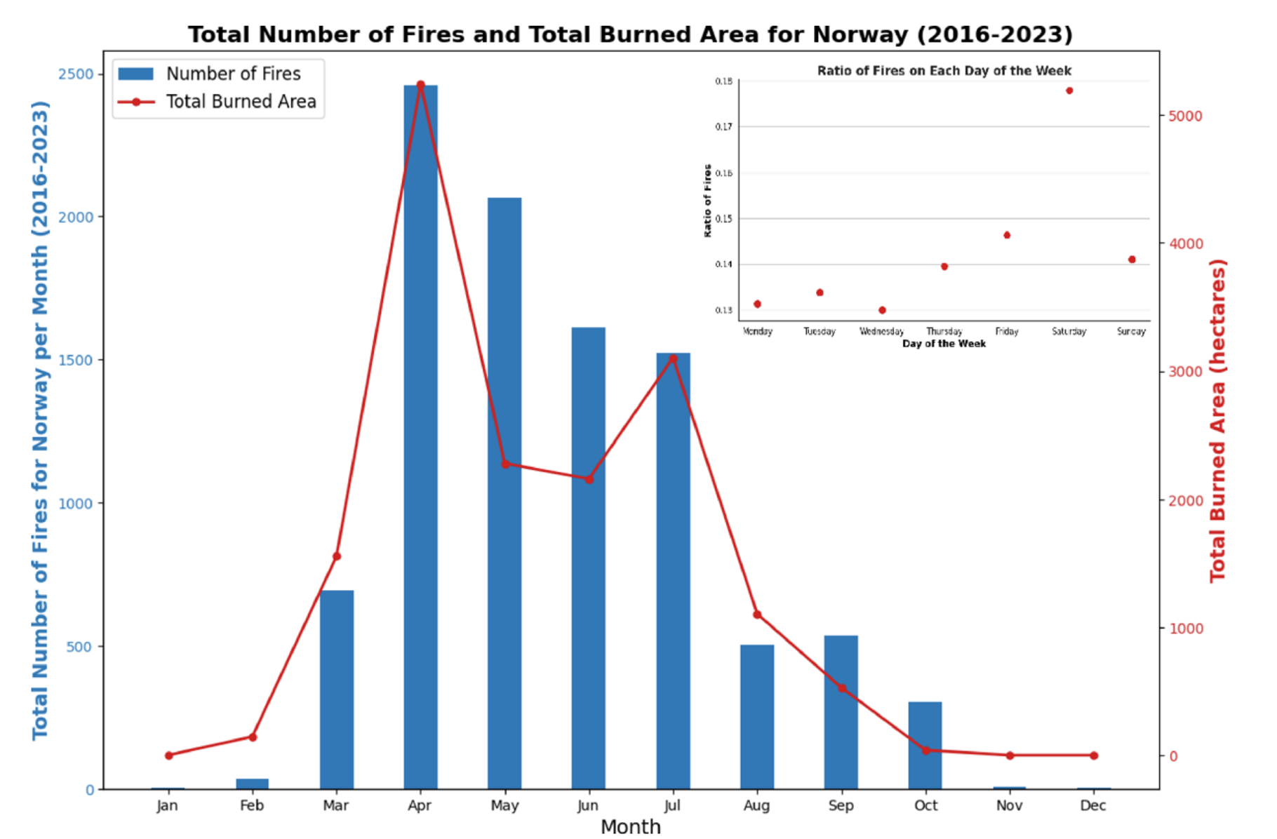
Monthly distribution of wildfires in Norway, showing a clear peak during spring (April–May).
Preparedness efforts often focus on summer, but this pattern shows that spring awareness and prevention measures are equally crucial.
Human activity remains the leading ignition source. Analysis of fire occurrence by weekday shows that Fridays and Saturdays consistently have the highest counts, likely due to outdoor recreation, barbecues, and grass burning (Fig. 3). Human-caused ignitions account for the majority of wildfires in the country.
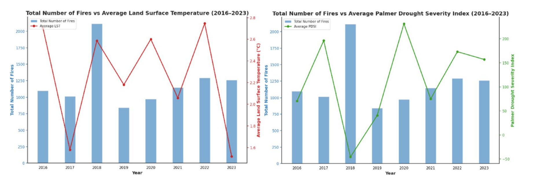
2018- When Climate Conditions Aligned
The extreme wildfire activity in 2018 was strongly associated with unusual climatic conditions. Analysis of drought indicators and weather variables shows:
- Prolonged low precipitation
- Elevated land surface temperatures
- Severe drying of soil and vegetation
- Strong drought signals in the Palmer Drought Severity Index (PDSI)
These factors created conditions where fires could ignite more easily and spread more rapidly.
Figure 4 – Drought severity and climate anomaly (2018)
Drought and climate anomalies during 2018, illustrating extreme drying conditions linked to increased wildfire activity.
The 2018 season demonstrated how quickly Norway’s wildfire risk can escalate when heat, drought, and wind occur together. Climate projections suggest such conditions may become more frequent, meaning high-risk seasons could appear more often.
A Changing Trend
When comparing wildfire activity across recent years, variations become clear. Some years show moderate activity, while others , like 2018 stand out due to extreme climatic drivers.
Figure 5 – Annual wildfire trend (2016–2023)
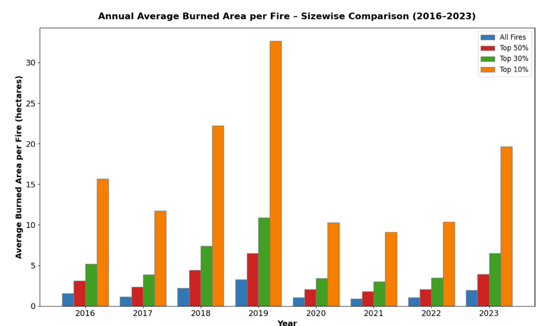
Annual number of wildfires and/or burned area in Norway, illustrating interannual variability and extreme seasons.
This variability suggests that wildfire risk in Norway is becoming more influenced by climate extremes, rather than following stable historical patterns.
Why Is the Risk Increasing?
The rising wildfire risk results from a combination of environmental and societal factors:
- Climate change leading to hotter and drier periods
- Increased recreational use of forests
- Vegetation and land-use changes
- Expansion of the wildland–urban interface (WUI)
Wildfires are therefore no longer only ecological events. They are complex risk scenarios involving communities, infrastructure, and emergency services.
How prepared is Norway today?
Norway’s fire protection system is well established for urban and structural fires but remains less developed for vegetation fires. Three key legislative documents form the foundation of Norwegian fire safety:
- The Fire and Explosion Protection Act (2002)
- The Fire Prevention Regulation (2016)
- The Regulation on Fire and Rescue Services (2022)
While these frameworks mention vegetation fires, they do not specifically define strategies for wildfire prediction, fuel management, or landscape planning. Responsibility for prevention and response largely rests on municipalities. This creates unequal capacity across the country , smaller municipalities often lack both personnel and specialized equipment for large-scale wildfires.
Out of approximately 600 fire stations, only around 70 have wildfire-specific tools or training. According to DSB’s national survey, fewer than 20 percent of stations conduct annual vegetation fire exercises. This capacity gap makes coordination essential during emergencies.
Since 2018, several reforms have improved national readiness. DSB introduced a national helicopter standby system from April 15 to August 15 each year, ensuring aerial firefighting resources are available during the critical period. Rogaland brann og redning IKS acts as the national coordination hub.
Table 1
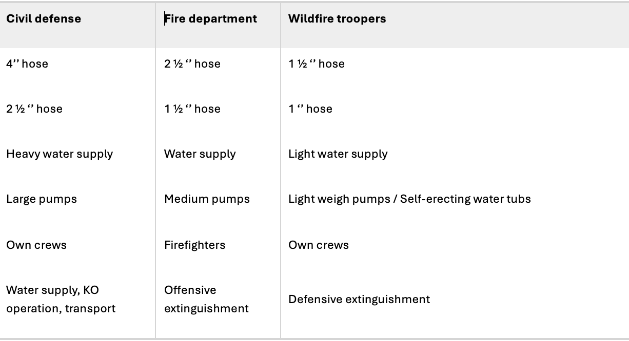
The “Telemark model” has become a best-practice structure for integrated response. It promotes cooperation between local brigades, civil defence units, volunteer groups, and forestry organizations. This networked approach allows rapid scaling of resources in high-risk periods. Table 1 in the study summarizes how these partnerships operate across Norway.
Table 1 –Overview of the wildfire management and coordination framework in Norway.
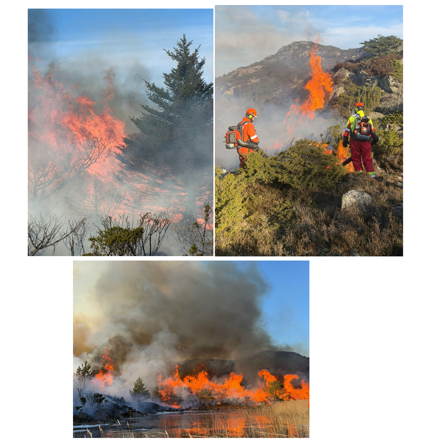
Prescribed burning is increasingly recognized as an important tool for reducing wildfire risk. By intentionally burning vegetation under controlled conditions, fuel loads such as dry grass, shrubs, and forest litter can be reduced before extreme weather occurs. This lowers fire intensity, slows potential wildfire spread, and creates safer conditions for firefighters. Prescribed burns can also improve ecosystem health by supporting natural regeneration processes. When carefully planned and coordinated with fire services and environmental authorities, this practice can be an effective part of Norway’s long-term wildfire prevention strategy.
Figure 6 – Prescribed burn practice in 2026.
What still needs to be done
Despite notable progress, several areas remain critical for improving Norway’s wildfire preparedness:
- Fire data must include ignition points, vegetation type, fuel moisture, and weather at the time of ignition. This will improve forecasting models.
- Fire brigades across Norway should follow a unified training curriculum developed jointly by DSB and academic partners.
- Controlled burning, vegetation maintenance, and fuel reduction should be encouraged in high-risk landscapes.
- Early warning systems using satellite imagery, drones, and AI models can detect ignition patterns and predict spread.
- Campaigns targeting recreational fire use, and stricter guidelines for houses near forests are essential.
Simple preventive actions also matter, clearing dry grass, maintaining firebreaks, and avoiding open fires during droughts are practical steps that significantly reduce ignition potential. Prevention is always cheaper and safer than suppression.
From Reaction to Anticipation
Wildfires in Norway are no longer rare, isolated events. They are part of a gradually evolving risk environment, shaped by climate and societal change. The events of 2018 served as a warning of how quickly conditions can escalate.
Understanding recent patterns allows Norway to move from reacting to individual fires toward anticipating seasons of elevated risk, protecting forests, communities, and emergency personnel in a changing climate.
The way forward
The 2018 wildfire season was a wake-up call. It demonstrated how quickly multiple small fires can escalate into national-scale emergencies. Figures 3 and 4 show that while the total number of fires remains high, the burned area fluctuates depending on extreme weather events. This confirms that climate is now the dominant control factor in Norway’s fire regime.
The future will likely bring longer fire seasons, more ignitions, and greater challenges for local services. However, Norway’s strong institutional framework, combined with new research, provides an opportunity to build resilience before the next major event.
Investing in knowledge, data, and local competence will be key. Collaboration between DSB, municipalities, and universities along with public engagement, can ensure that the next wildfire season finds Norway better prepared than the last.
Author introduction
Warda Rafaqat is a PhD candidate at the Western Norway University of Applied Sciences and the University of Bergen. Her research focuses on wildfire ignition and spread modelling in Scandinavia, integrating climate analysis, fire dynamics, data modelling, and risk assessment to support improved wildfire preparedness and management. She collaborates with academic and operational partners in the fire safety field and has presented her work at international fire safety forums. Her recent paper, “Analysing historical events and current management strategies of wildfires in Norway,” was published in Scientific Reports (Nature Portfolio) in 2025.